
Lixel K2 — The Gold Standard in Lightweight SLAM Scanning
A handheld SLAM LiDAR scanner with onboard RTK, delivering survey-grade point clouds and 3D Gaussian Splat models in a single 1.2kg device. Walk the site, capture everything — no tripods, targets or GCPs required.
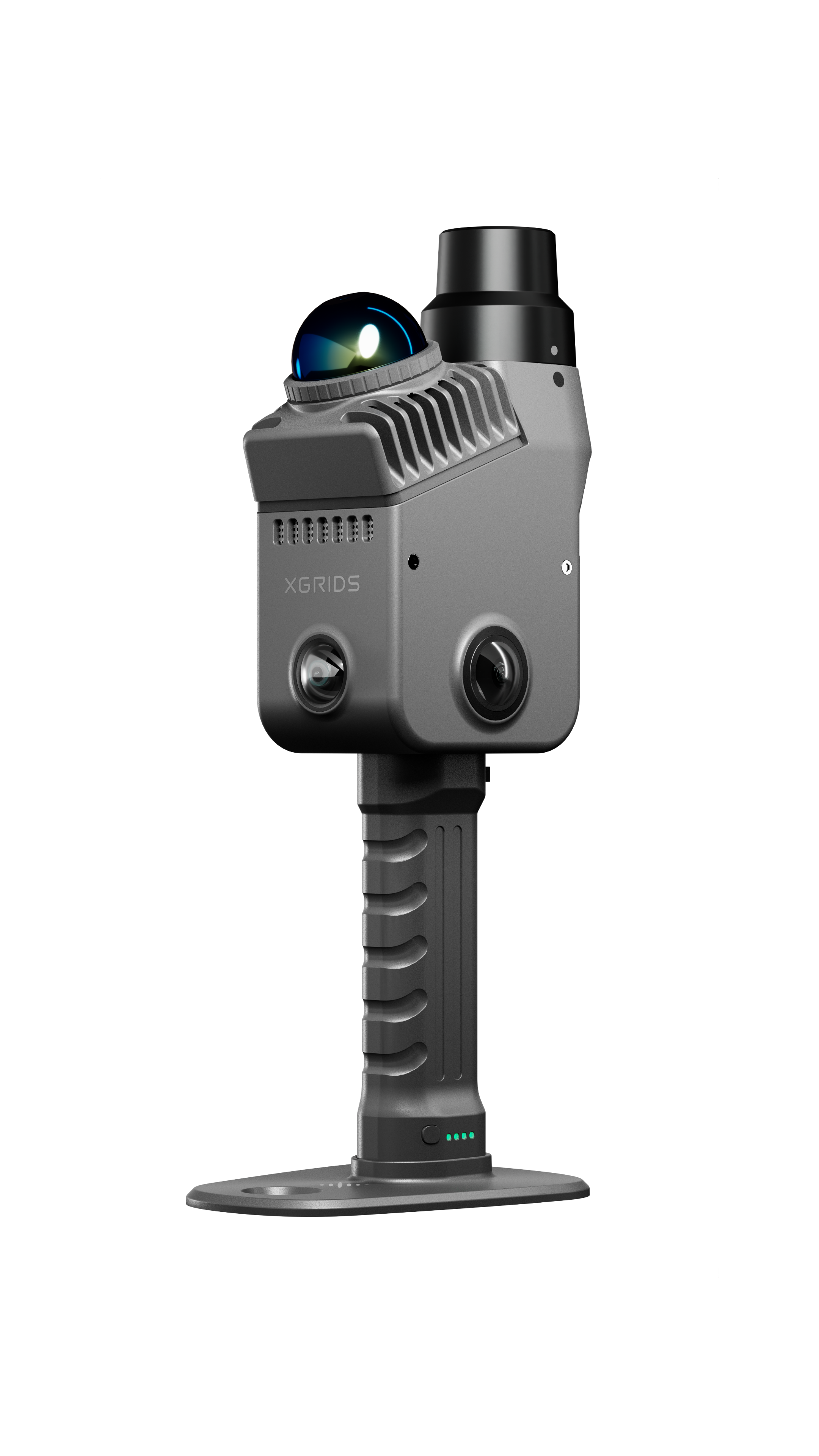
Lixel K2
Handheld SLAM LiDAR Scanner · XGRIDS
1.2 kg · Onboard RTKSurvey-Grade Handheld Scanning, Redefined
The Lixel K2 fuses LiDAR, visual and inertial SLAM with an onboard RTK module to deliver centimetre-level accuracy without ground control points. Three cameras — two fisheye and one forward-facing at 4000×3000 resolution — capture full 360° × -7° to +52° coverage alongside the point cloud.
Data is processed through XGRIDS' LixelGo app for one-click on-device reconstruction, or LixelStudio for full desktop registration, classification and export — including native 3D Gaussian Splatting for photoreal digital twins.
Centimetre-level absolute positioning, no GCPs needed
LiDAR + visual + inertial SLAM for robust tracking
Point cloud + photoreal 3D model from one scan
1.2kg lightweight design for all-day fieldwork
Key Benefits
Walk-and-scan workflow replaces static setups — cover large sites in a fraction of the time.
One operator can complete what previously needed a full survey crew.
Get both a survey-grade point cloud and a photoreal 3D model simultaneously.
Sentra provides demos, training and after-sales support as official reseller.
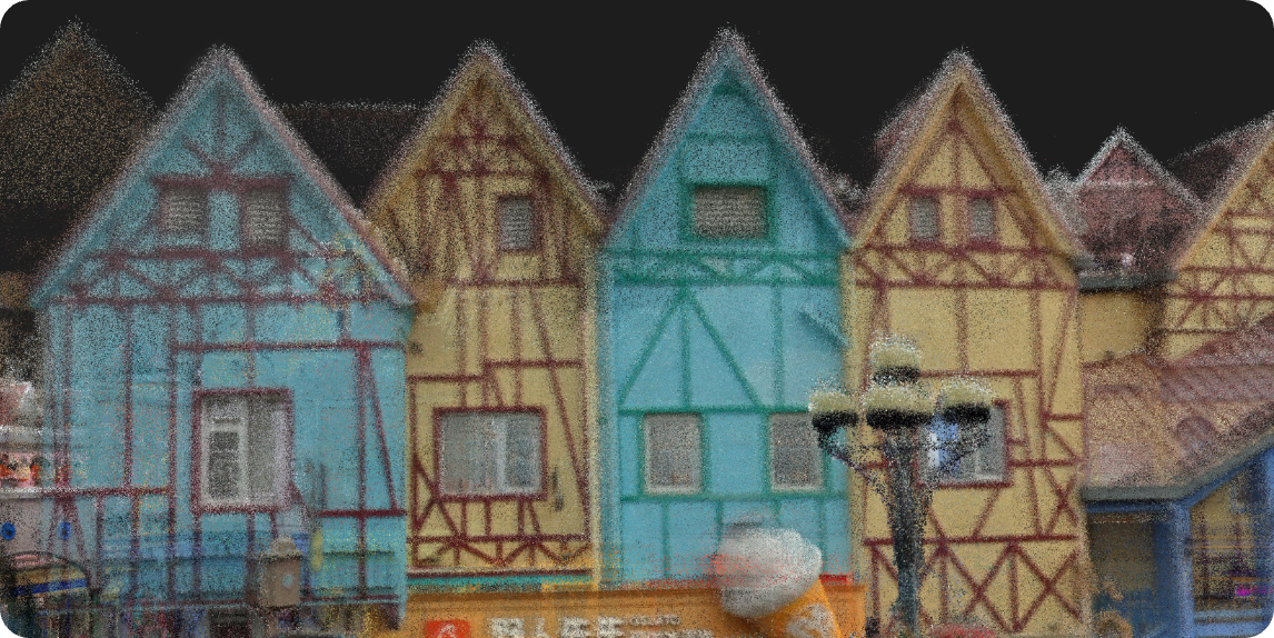
Reconstruction Starts with Spatial Perception
Smarter processing. More power. The Lixel K2 captures complete environmental detail with a multi-sensor fusion system built for accuracy.
Real-Time Spatial Perception System
Fuses LiDAR, visual and inertial SLAM data in real time for robust tracking and reconstruction — even in featureless or dynamic environments.
Complete Environmental Detail, Captured
Three cameras — two fisheye plus one forward-facing at 4000×3000 — deliver full 360° × -7° to +52° coverage alongside the point cloud.
Spatial Coordinates, Precisely Locked
Built-in UM980 RTK module delivers centimetre-level absolute positioning — RTK and PPK supported, no ground control points required.
Lightweight Device. Engineering-Grade Data.
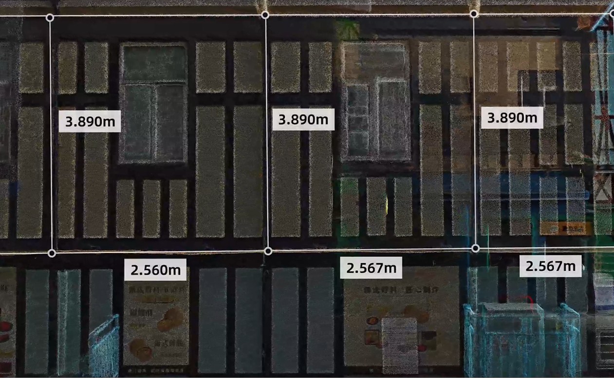
Measurement Accuracy
Wall distances and window dimensions you can rely on — relative accuracy within 1 cm.
Point Cloud Thickness
Fine detail, faithfully reproduced — post-processed point cloud thickness as thin as 1 cm.
Point Clouds, True to Life
Complex Geometry
Clearly resolved — intricate structures captured with precision.
Uniform Colorization
Every detail, visible — consistent true-colour across the entire scan.
Denser Point Clouds
Truer detail — 200,000 pts/sec for high-density capture.
Low-Light Performance
Still sharp — LiDAR-based capture works in any lighting condition.
Engineering-Grade
Built for precision — survey-grade output you can build on.
One Device. Any Scenario.
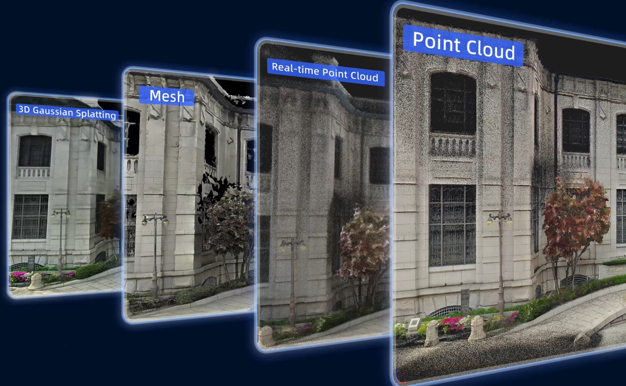
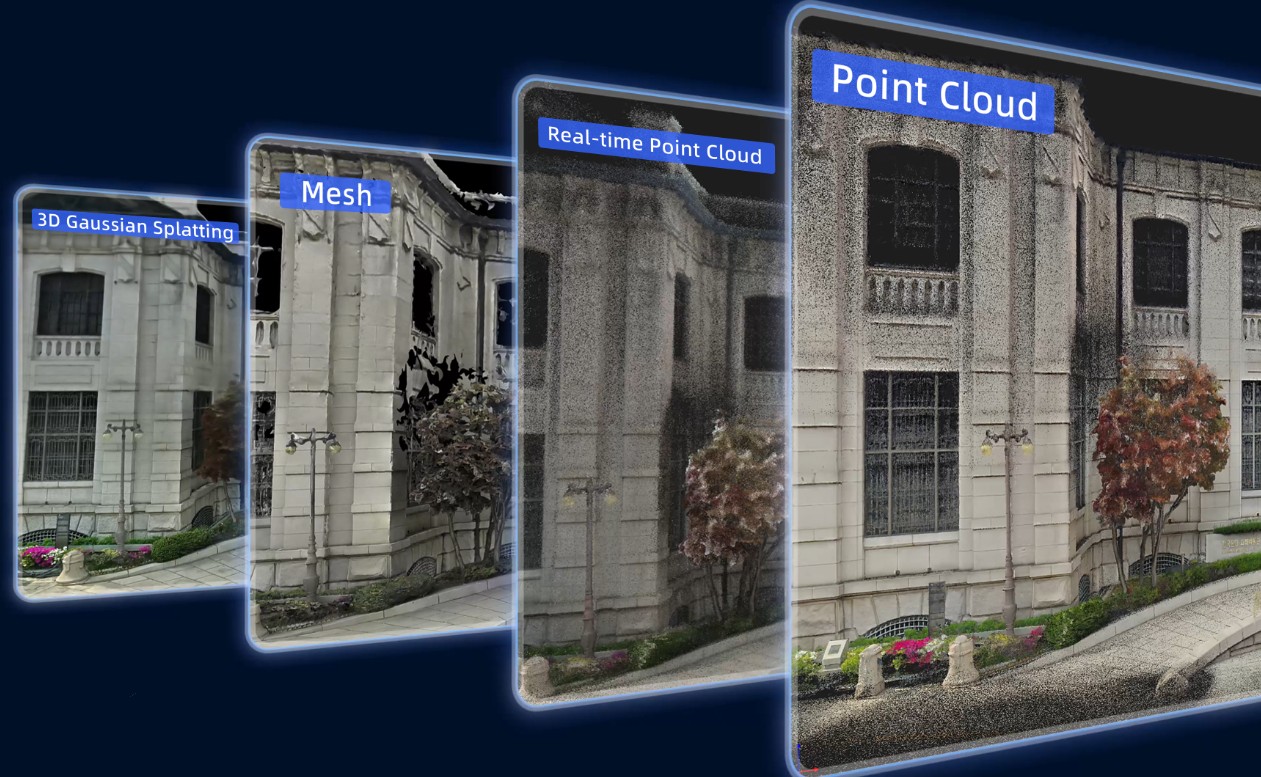
One scan, multiple outputs — each matched to the task.
Real-Time Point Cloud
Post-Processed Point Cloud
Mesh
3D Gaussian Splatting
Real-Time Point Cloud
On-site assurance for urgent projects. Assess data quality as you scan — verify coverage, check alignment and confirm completeness before leaving the site.
Post-Processed Point Cloud
The foundation for high-precision, engineering-grade deliverables. Full registration, classification and optimisation through LixelStudio for survey-ready output.
Mesh
Editable, structured 3D models, generated fast. Watertight meshes ready for CAD integration, volume calculations and visual presentations.
3D Gaussian Splatting
Spatial reconstruction at peak fidelity and realism. Photoreal, walkable 3D environments for digital twins, virtual tours and immersive experiences.
The Lixel K2, In the Field
From Data to Delivery. The Full Loop, Closed.
Your entry point into spatial intelligence. When you choose Lixel K2, you tap into XGRIDS' complete spatial intelligence platform.
Digital Twin
Rapidly digitize real spaces for visual management and ongoing operations — from facility monitoring to remote collaboration.
Scan-to-BIM
Streamline the point-cloud-to-model workflow, delivered to engineering standards — from raw scan to classified, usable BIM models.
NVIDIA Isaac Sim
Feed real-world data into simulation training to accelerate robot perception and decision validation — bridging physical and digital worlds.
What Makes the Lixel K2 Different
Onboard RTK
Integrated RTK module delivers 3cm absolute accuracy on both elevation and horizontal axes — no ground control points needed.
Triple Camera Array
Two fisheye cameras plus one forward-facing camera at 4000×3000 resolution deliver full 360° × -7° to +52° coverage.

Native 3D Gaussian Splatting
Generate both a classified point cloud and a photoreal Gaussian Splat model from a single walk-through capture.
1.2kg Lightweight Design
Compact, one-hand ergonomics for extended field sessions without operator fatigue.
LixelGo One-Click Processing
On-device app for instant preview and one-click registration in the field — no laptop required.

Open Export Formats
Export to LAS, LAZ, E57, PLY and Gaussian Splat — compatible with CAD, BIM and 3D engine pipelines.
Where the Lixel K2 Excels
AEC & As-Built Documentation
Rapid as-built capture for renovation, BIM coordination and construction verification.
Industrial & Plant Scanning
Confined-space and facility scanning for retrofit design and asset documentation.
Real Estate Digital Twins
Fast, photoreal walkthroughs for property listings and facility management.
Heritage Documentation
Non-invasive, high-fidelity capture of heritage structures and monuments.
Lixel K2 Specifications
| Scan Range | ≥40m @ 10% reflectivity, up to 100m max |
|---|---|
| Point Rate | Up to 200,000 points/sec |
| Relative Accuracy (RMSE) | 1 cm |
| Absolute Accuracy — Elevation (RMSE) | 3 cm |
| Absolute Accuracy — Horizontal (RMSE) | 3 cm |
| Repeatability | 2 cm |
| Post-Processed Point Cloud Thickness | ≤ 1 cm |
| Real-Time Absolute Accuracy (RMSE) | 3 cm (elevation & horizontal) |
| Positioning | Onboard RTK module (UM980) — RTK & PPK supported |
| Cameras | 3× (2 fisheye + 1 forward-facing), 4000×3000, 1/2" CMOS |
| Field of View | 360° × -7° to +52° |
| Laser Class | Class 1 / 905 nm |
| Weight | 1.2 kg (incl. battery & base) |
| Housing | Aviation-grade aluminum |
| Internal Storage | 512 GB eMMC |
| Data Interface | USB 3.1 Gen2 |
| Battery Life | 1.5 hours |
| Operating Temperature | -20°C to +50°C |
| IP Rating | IP54 |
| Output Formats | LAS, LAZ, E57, PLY, 3D Gaussian Splat |
| Software | LixelGo (mobile) · LixelStudio (desktop) |
Need the full technical datasheet?
Download the complete Lixel K2 brochure
One Software Ecosystem. Full Pipeline.
LixelStudio
Point Cloud Processing Workstation
Upgraded for higher-quality data output — the desktop companion for full registration, classification and export of Lixel K2 captures.
Upgraded for Higher-Quality Output
Included Accessories
Phone Mount
Securely attach your smartphone for live LixelGo app monitoring during scan sessions.
IncludedExtension Pole
Reach higher vantage points for elevated captures — ideal for large interiors and overhead structures.
Got Questions About the Lixel K2?
Can't find what you're looking for? Contact our team — we're happy to help.
No. The onboard RTK module provides centimetre-level absolute positioning during capture, eliminating the need for ground control targets in most projects.
Yes — the Lixel K2 natively generates 3D Gaussian Splat models alongside the classified point cloud, so you get a photoreal 3D asset from the same scan.
LAS, LAZ, E57 and PLY point cloud formats, plus 3D Gaussian Splat files compatible with Unreal Engine, Unity and Blender.
Yes. As the official XGRIDS reseller in India, Sentra provides on-site demos, operator training, calibration support and warranty service.