
GNSS Meter
A high-precision GNSS positioning sensor for automated monitoring of surface point movements. Utilizes multi-band Real-Time Kinematic (RTK) technology to deliver sub-centimeter positioning accuracy — down to 2 mm for 24-hour aggregated values.
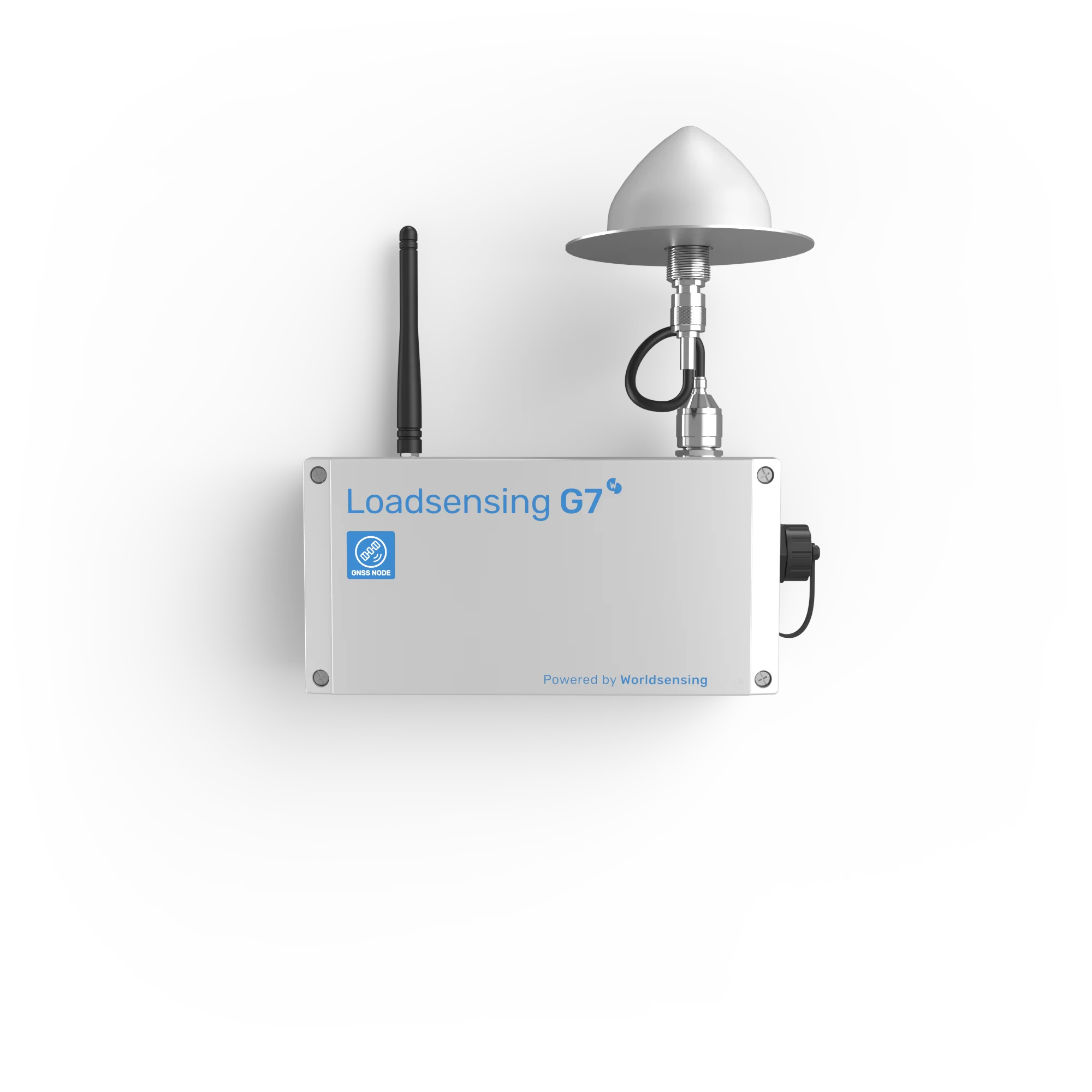
GNSS Meter
Model: LSG7GNS-SXLH
Base & Rover ModesMillimeter-Level Displacement Detection for Infrastructure
The GNSS Meter is a precision positioning sensor for long-term, continuous monitoring of bridges, tunnels, buildings, and slopes. It captures millimeter-level displacements using high-precision GNSS technology with RTK correction, with onboard algorithms to detect movement automatically.
Supports flexible configuration as both a base and a rover. Data is transmitted via LoRa radio to the CMT platform for real-time visualization and analysis. Integrated tiltmeter and environmental sensors provide enhanced reliability for critical monitoring applications.
Real-time kinematic correction
GPS, GLONASS, Galileo, BeiDou
3-axis MEMS, ±90° range
Base & Rover operation
What Makes the GNSS Meter Different
Purpose-built for automated displacement monitoring with multi-constellation RTK precision and long-range wireless data transmission.
Multi-Constellation RTK
184 channels tracking GPS/QZSS, GLONASS, Galileo, and BeiDou. RTK correction technology delivers sub-centimeter accuracy for reliable displacement detection.
Long Battery Life
Powered by 4 × 3.6V D-size user-replaceable batteries. Up to 3.5 years of unattended operation (rover mode, 10s warmup). Flexible warmup time selection (10s, 20s, 30s).
IP68 Rated & Rugged
Industrial-grade IP68 enclosure for full submersion protection. Operating range from −40°C to +80°C — suitable for the harshest field conditions.
Integrated Sensors
Built-in 3-axis tiltmeter (±90°) and environmental sensors (temperature & humidity) for enhanced data reliability and system health monitoring.
Cloud & Edge Management
Configure locally via CMT Edge for single-network deployments, or connect to CMT Cloud for multi-project, multi-network oversight from anywhere.
Mobile App Configuration
Wireless Bluetooth setup via Worldsensing App. Flexible warmup time and reporting period configuration for optimized power usage.
Displacement Monitoring for Every Environment
Explore the range of monitoring solutions enabled by the GNSS Meter across structural, geotechnical, and infrastructure applications.
Structural Monitoring
Bridge Displacement
Monitor long-term bridge deformation, settlement, and thermal movement with millimeter-level GNSS positioning. Detect structural changes before they become critical.
Tunnel Portal Stability
Track ground movement at tunnel entrances and along alignment. Early detection of settlement or heave that could affect tunnel integrity.
Building Settlement
Monitor tall building and foundation settlement over time. RTK precision enables detection of differential settlement at millimeter scale.
Dam Deformation
Continuous monitoring of dam crest displacement and deformation patterns for safety assurance and regulatory compliance.
Geotechnical & Infrastructure
Landslide Monitoring
Deploy GNSS meters on landslide-prone slopes for continuous surface displacement tracking with early warning capabilities.
Rail Track Alignment
Monitor railway track geometry and ground settlement along alignment. Ideal for high-speed rail and critical transport corridors.
Mining Pit Stability
Track pit wall movement and bench deformation in open-pit mining operations for personnel and equipment safety.
Tailings Dam Monitoring
Critical displacement monitoring of tailings storage facilities with automated alerts for early warning of potential failure.
GNSS Meter Specifications
| Sensor Type | GNSS with RTK correction |
|---|---|
| Secondary Sensors | Tiltmeter (3-axis MEMS) • Temperature & humidity |
| GNSS Channels | 184 |
| Constellations | GPS/QZSS (L1C/A, L2C) • GLONASS (L1OF, L2OF) • Galileo (E1-B/C, E5b) • BeiDou (B1I, B2I) |
| Correction Technology | Real Time Kinematic (RTK) |
| Power Source | 4 × 3.6V D-size user-replaceable batteries |
| Reporting Period | 1 h (configurable) |
| Data Transmission | LoRa radio (ISM sub GHz) |
| Operating Temperature | −40°C to +80°C |
| Weather Protection | IP68 |
| GNSS Time Sync | ±1s |
| System Configuration | Worldsensing App • CMT Edge • CMT Cloud |
| GNSS Precision & Battery Data | ||||||||||||||||||||||||||||||||||||||
|
Correction: RTK
Tilt Range: ±90°
Power: 4× D-size
|
Best precision:
2 mm (24h, horizontal)
GNSS Precision (95th Percentile) — RTK mode
Battery Life Estimations (1 h reporting period) |
||||||||||||||||||||||||||||||||||||||
Need the full technical details?
Complete specs, diagrams, and compatibility info
Flexible Mounting for Any Environment
Choose the mounting configuration that best fits your deployment site.
Pole Mounting
Using aluminum plate WS-ACC-POLE-PL8 with 35 mm or 50 mm u-bolts for secure attachment to poles and posts.
Wall Mounting
Using external mounting brackets LS-ACC-MEC-MP (set of 2) for secure wall installation in tunnels and structures.
Horizontal & Surface Mounting
Using versatile plate LS-ACC-IN15-HP for horizontal and vertical surface deployment.
Got Questions About the GNSS Meter?
Can't find what you're looking for? Contact our team — we're happy to help.
It captures precise 3D positioning and displacement of structures, slopes, tunnels, and other critical infrastructure, detecting even millimeter-level movements using RTK-corrected GNSS technology.
With RTK correction at 40 m baseline: 2 mm horizontal and vertical precision (95th percentile, 24h aggregated). At 4000 m baseline: 4 mm horizontal and 7 mm vertical (24h aggregated).
The GNSS Meter tracks 4 constellations: GPS/QZSS (L1C/A, L2C), GLONASS (L1OF, L2OF), Galileo (E1-B/C, E5b), and BeiDou (B1I, B2I) across 184 channels for reliable positioning in any environment.
Battery life depends on warmup time and mode. In rover mode with 10s warmup: 3.5 years. With 30s warmup: 2.5 years. Base mode: 3.1 years (10s) to 2.4 years (30s). Powered by 4 × D-size batteries.
Yes — data is provided via MQTT, REST API, or FTP, making it easy to integrate into SCADA, asset management, or custom monitoring platforms. Compatible with CMT Edge and CMT Cloud.
Ideal for bridges, tunnels, retaining walls, slopes, rail lines, dams, and any infrastructure requiring precise positioning and early detection of movement.